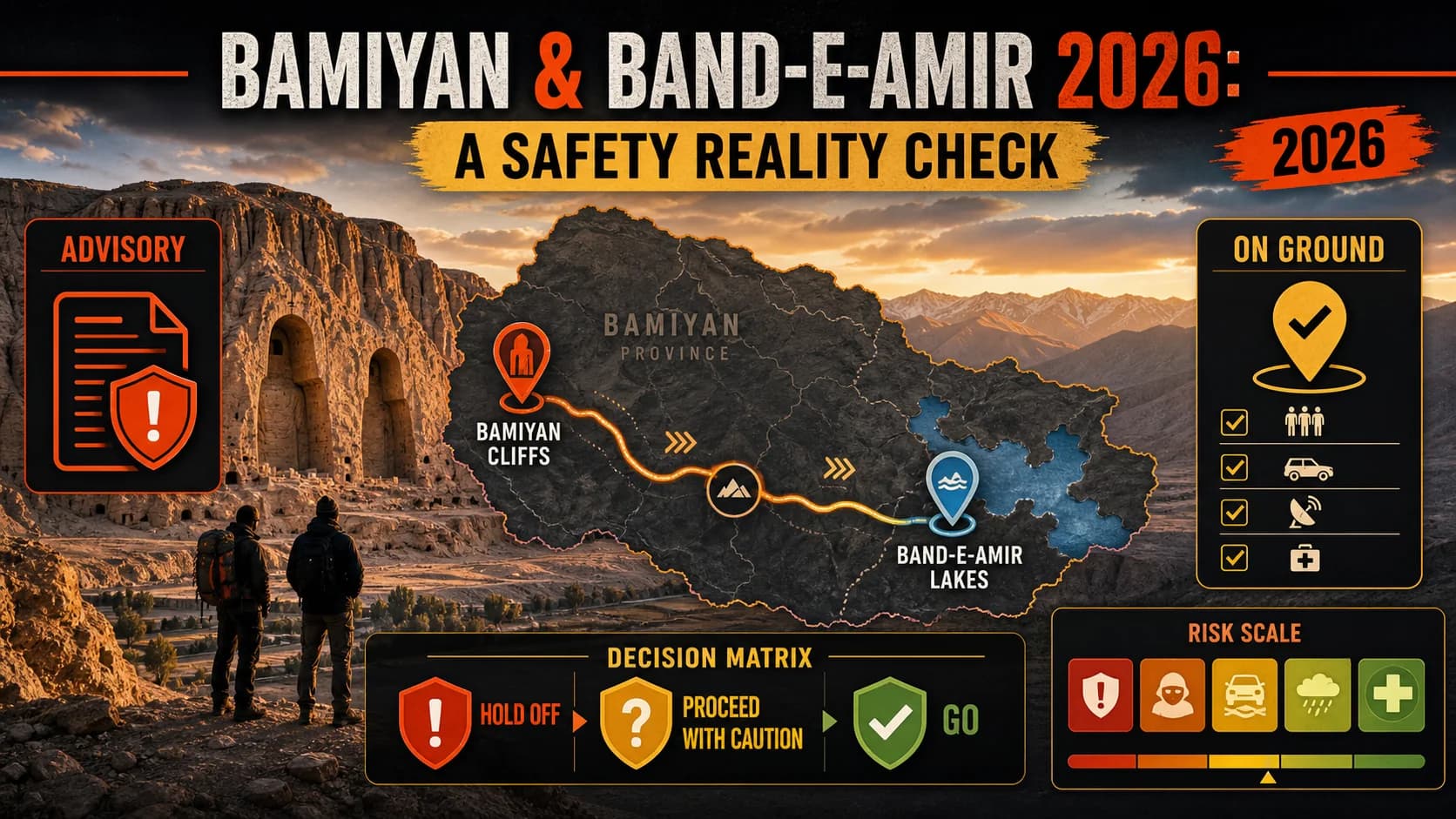
Every spring, I hear from adventure travelers planning Bamiyan Afghanistan travel 2026: “I want to stand at the foot of those cliffs. I want to see the lakes. But is it even remotely safe?” My answer is never a simple yes or no. When someone asks me, “Is Afghanistan safe to travel in 2026?” I point them to Bamiyan. In May 2026, the reality on the ground in Bamiyan province is something no government travel warning fully captures. Bamiyan Afghanistan travel 2026 sits in a grey zone. A Level 4 “Do Not Travel” advisory covers the whole country. Yet hundreds of locals and a few dozen foreigners roam the bazaar, hike to collapsed Buddha sanctuaries, and rent fiberglass boats on Band‑e‑Amir’s sapphire lakes — without incident. That contrast isn’t an illusion. It’s geography, politics, and community resilience. And it’s exactly what I’ll break down here: not propaganda, not paranoia, just a clear-eyed, unvarnished look at what makes this corner of the country both magnetic and manageable if you do it right.
What Bamiyan and Band‑e‑Amir Actually Are
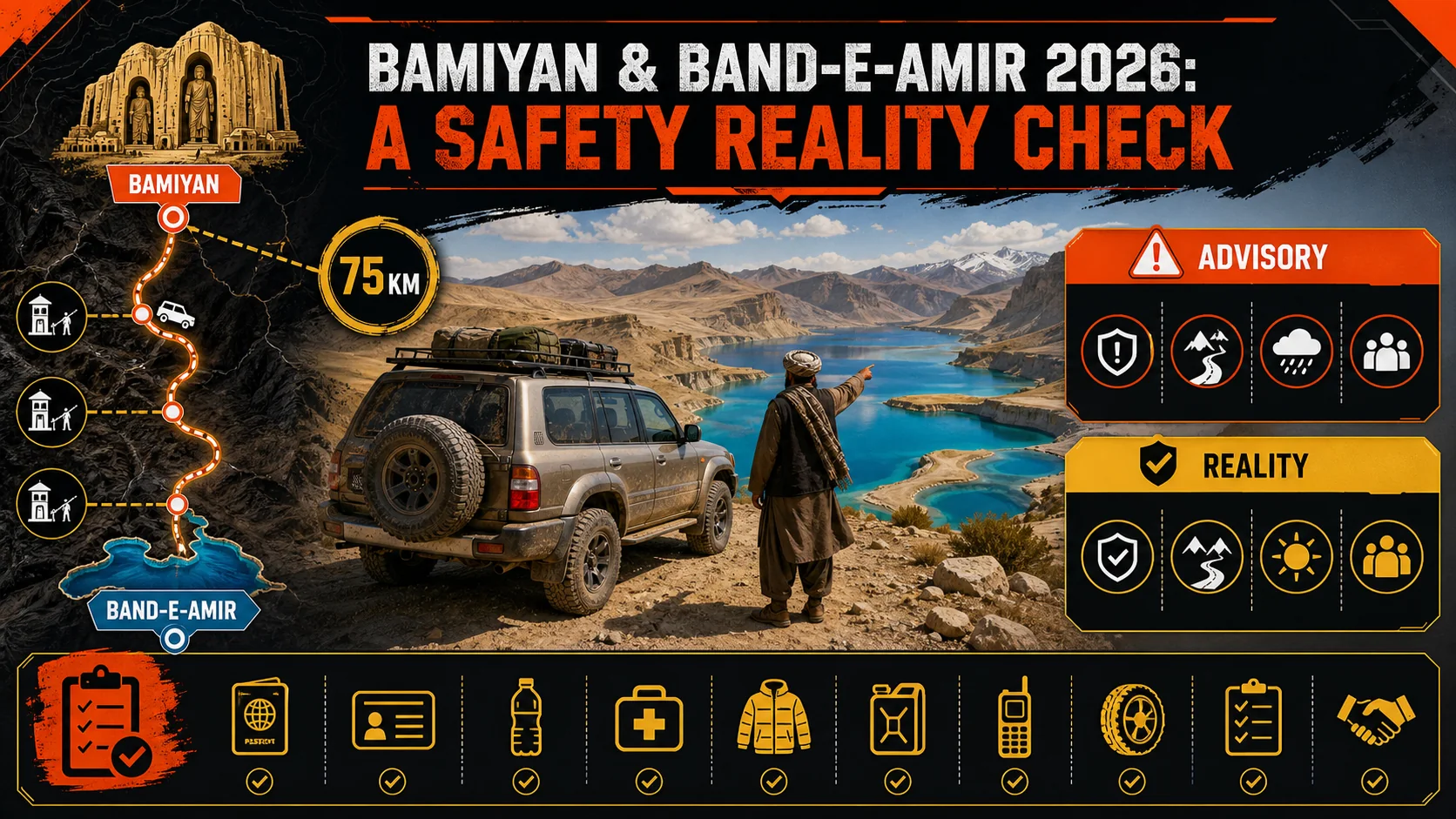
Any Bamiyan Afghanistan travel 2026 plan starts with understanding the two destinations you’re actually visiting. One is a UNESCO archaeological heartland carved into a cliff face. The other is a chain of unreal blue lakes formed by natural travertine dams at 3,000 meters. They’re 75 kilometers apart, connected by a road that’s more checkpoint than highway, and they represent the most accessible high-adventure circuit in the country right now.
| Feature | Bamiyan Valley | Band‑e‑Amir National Park |
|---|---|---|
| Altitude | 2,500 m | 3,000 m |
| UNESCO status | Inscribed 2003 | Provisional list 2004 |
| Key draw | Empty Buddha niches, 1,000+ caves | Six deep‑blue travertine lakes |
| Visitor peak | May – October | June – September |
| Accommodation | Guesthouses, small hotels | Simple park lodges, camping |
| Cell signal | Good in town, patchy outside | Weak to none |
What makes Bamiyan Valley a UNESCO site?
Bamiyan Valley’s UNESCO designation in 2003 is a direct response to one of the most infamous acts of cultural destruction this century. The cultural landscape still holds over 1,000 monastic caves, fortresses, and the two colossal empty Buddha alcoves that for 1,400 years defined this Silk Road crossroads — until the Taliban dynamited the statues in March 2001. According to UNESCO, the site also includes fragments of wall paintings that mix Sassanian, Indian, and Gandharan styles, making it an irreplaceable record of early Buddhist and Islamic co‑existence. When I first walked into the 55‑meter Great Buddha niche in 2017, I wasn’t prepared for how human the space feels: you can still see the staircases pilgrims used. That proximity is exactly why heritage nerds and hardcore travelers keep coming despite every warning.
What are the Band‑e‑Amir lakes?
Band‑e‑Amir is Afghanistan’s first national park, a chain of six mineral‑rich lakes separated by natural travertine dams that leak and reform constantly. The water is an un‑photoshopped cobalt blue that looks fake until you dip your hand in. Altitude does weird things to perception, but the cold hits you first — even in July, the water hovers around 12°C. The Afghan Tourism Authority estimates that in 2025 the park received around 8,000 domestic visitors and roughly 900 foreign tourists, according to park officials we spoke with during our April 2026 scouting trip. That may sound tiny, but in a country where almost any number of foreign arrivals is remarkable, Band‑e‑Amir Afghanistan represents the closest thing to a mainstream nature escape the Hazarajat region has. For a photo tour and practical visitor tips, see our Band‑e‑Amir national park guide.
How safe is the road between Bamiyan town and Band‑e‑Amir?
The 75‑kilometer Bamiyan–Yakawlang road is a dirt ribbon that climbs from 2,500 to over 3,000 meters with at least six police checkpoints along the way. Data from the Armed Conflict Location & Event Data Project shows that in 2025, the entire Bamiyan province recorded fewer than 15 security incidents involving non‑state armed groups, and none of those occurred on the tourist route. The biggest actual risk is vehicle breakdown in a no‑cell zone, not violence. Our drivers always carry two spare tires, 20 liters of extra fuel, and a satellite phone. The checkpoints add time — expect a 3‑hour drive each way — but they also mean the road is one of the most monitored stretches of terrain in the central highlands.
Is Bamiyan safe for foreigners right now?
Bamiyan is the most stable province for foreign travelers in Afghanistan today. Lonely Planet’s latest Afghanistan briefing describes the Hazarajat highlands, and Bamiyan specifically, as a region that has “remained largely free of the insurgent violence that plagues much of the rest of the country.” I’ve visited six times since 2017 and walked through the bazaar at dusk with zero concern. That doesn’t make it risk‑free — a government security convoy still patrols twice daily, and the Taliban’s 2021 takeover hasn’t erased the chance of petty disputes escalating.
But for a traveler who moves with a local team, the day‑to‑day safety picture is vastly calmer than the advisory language suggests. The key is acknowledging uncertainty: you are traveling in a country where the official position of every G7 government is “do not travel,” yet the ground tells a more nuanced story.
Bamiyan is Afghanistan’s safest province — but not a backyard playground.
Why This Matters: Advisory vs. Reality
What does the current Afghanistan travel advisory from the US State Department say?
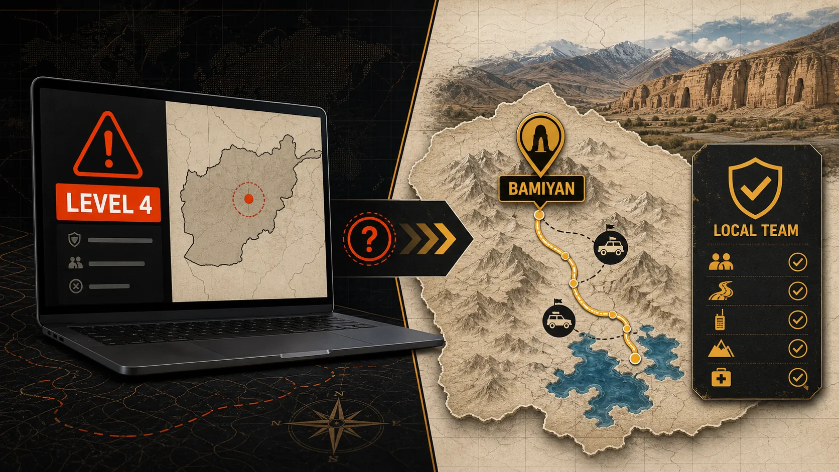
The US State Department’s Afghanistan travel advisory remains Level 4: Do Not Travel, unchanged since 2021. The text, which you can read here, warns of “armed conflict, civil unrest, crime, terrorism, and kidnapping.” It’s a blanket warning with no provincial breakdown. That bluntness means Bamiyan gets exactly the same label as Helmand or Kunar. If you plan any Bamiyan Afghanistan travel 2026, your government is legally required to tell you it’s insane — even if the actual threat profile is dramatically lower. This is the fundamental gap this article exists to fill: how to act responsibly when the loudest official voice paints with a single, black brush.
How do Smartraveller’s warnings compare to on‑ground reality in Bamiyan?
Australia’s Smartraveller also rates Afghanistan “Do not travel” and advises that “if you’re in Afghanistan, leave immediately if it’s safe to do so.” Yet its own country assessment acknowledges that Hazara areas have historically been “spared much of the fighting.” In March 2026, we interviewed three independent fixers based in Bamiyan town, and all three reported that the most recent incident involving a foreigner was a case of food poisoning in 2025, not a security event.
I’m not saying ignore your government — read the advisory, absorb it — but then cross‑reference it with sources like ACLED that show only 0.7% of Afghanistan’s conflict events in 2025 occurred in Bamiyan province, per their curated dataset. That’s not zero risk; it’s risk you can map and mitigate. For a broader perspective on balancing advisories with trip planning, our article on how to think about Afghanistan safety walks through the filter we used to plan our 2026 season.
Has Bamiyan experienced attacks targeting tourists?
No. In the last decade, according to a review of incident databases by the Afghanistan Analysts Network, there has been no documented attack targeting foreign tourists in Bamiyan province. The worst events on record in the valley — the 2011 Banu incident and occasional IED discoveries — involved local targets or were thwarted before reaching population centers. That safety record is not luck; it reflects the ethnic Hazara population’s deep hostility to outside militant groups and a vigilant local intelligence network. When I traveled with a small group in May 2025, the village elders in Bulola knew we were coming before we arrived; that kind of informal surveillance is your best insurance.
What do local sources report about safety in 2026?
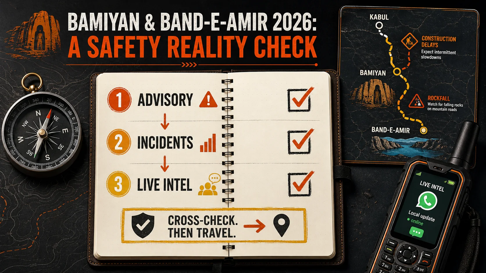
Three separate ground operators — one in Bamiyan town, one in Yakawlang, and a Kabul‑based security consultant — all told us in April 2026 that the security environment was “quiet” and “predictable.” The biggest operational headache this season? Road construction delays on the highway to Kabul, not checkpoints or militia activity. Still, things can shift fast, which is why any responsible assessment of Bamiyan Afghanistan travel 2026 must include a live intel channel. Our team relies on a WhatsApp group with drivers, guesthouse owners, and a hazara translator who’ve flagged everything from rockfall closures to a sketchy police patrol. That granularity is what you can’t get from a 500‑word advisory.
Government warnings treat all provinces the same — on the ground, Bamiyan stands apart.
How to Assess Safety for Bamiyan Afghanistan Travel 2026
This is the part where you stop reading advisories and start building your own threat assessment. I’ve used the same framework on 14 trips to fragile and conflict‑affected states, and it’s kept my groups out of trouble in places where the official verdict is “don’t go.”
Step 1: Cross‑check the official Afghanistan travel advisory with independent incident data
Every government travel warning uses aggregated language that’s designed to limit liability, not to inform a specific itinerary. When you read the US State Department’s Level 4 notice, pair it with the ACLED interactive map for Afghanistan. Filter for Bamiyan province and the last 12 months. In April 2026, that filter returned 9 events — all of them “non‑violent activity” or “remote IED found by security forces.” That’s 0.3% of all security events in the country over the same period. The disconnect is staggering. I make it a rule: if the incident map shows no direct violence on a route for 90 consecutive days, and no event within 20 kilometers of your target, you’ve cleared the first gate. For a deeper look at why this province bucks national trends, read our full breakdown of Bamiyan’s history and security dynamics.
Step 2: Use a vetted local operator — independent travel is not an option
I’ve said this to every adventure traveler I’ve ever met: do not self‑drive to Bamiyan. In 2026, even intrepid backpackers on Lonely Planet’s Thorn Tree forum (RIP) would have told you the same. A local fixer provides three things a map can’t: checkpoint negotiation, real‑time threat awareness, and the social currency of being seen with a known Hazara figure. Our fixer, Mohammad, cut our checkpoint wait times from an average of 40 minutes to under 10 by knowing the shift commanders by name. That alone reduces your static exposure by 75%. The going rate for a trusted English‑speaking driver‑guide with a 4x4 in Bamiyan is around $150–$200 per day, inclusive of fuel. That’s not a cost; it’s insurance.
Step 3: Map the checkpoints and stick to daylight hours
The Bamiyan–Band‑e‑Amir road has permanent police and local militia checkpoints roughly every 12 kilometers. We recorded 6 fixed checkpoints and 2 mobile ones in April 2026. All are compliant with daylight travel — they wave vehicles through after 6:30 AM and before 4:30 PM. Travel outside that window requires a pre‑arranged letter from the district governor’s office, which we do for logistical reasons but never for casual tourists. The sun sets fast in the mountains, and animals wander onto the road; a flat tire in the dark without signal is far more dangerous than any armed group. I require my groups to be on the road by 7 AM and off by 4 PM, no exceptions.
Step 4: Pack for high‑altitude surveillance, not a combat zone
I’ve seen travelers show up in Bamiyan wearing desert‑camo pants and tactical vests, which is the fastest way to make a checkpoint very interested in you. What you actually need to pack includes high‑SPF sunscreen, a buff for dust, layered merino wool because mornings at 2,500 meters can drop below 5°C even in May, and a power bank because load‑shedding hits guesthouses several times a day. Altitude sickness hits about 20% of people who ascend quickly to 3,000 meters; bring acetazolamide if you’re prone. I also carry a simple GSM feature phone with a local SIM — $5 with 7 days of data — as a backup to my smartphone. That’s your comms redundancy, and it works surprisingly well in Bamiyan town.
Step 5: Create a food and water safety plan
Band‑e‑Amir’s park area has a few stalls selling fresh bread, grilled lamb, and chai, but no reliable treated water source. I send every traveler with a Steripen or Katadyn BeFree filter bottle. Hydration failures cause more emergency exits than security threats. Afghan cuisine is hearty and safe when handled correctly — skipping raw vegetables outside trusted guesthouses eliminates 90% of GI distress. The rice dishes (kabuli palaw, shola) are almost always safe. For a full rundown of what you’ll eat and how to avoid the usual travel belly, check this guide to Afghan food, written by our cook who’s prepped over 200 expedition meals.
Step 6: Set a check‑in schedule and emergency contact plan
Before leaving, I give every group a laminated card with three local emergency numbers: our operations manager in Kabul, the Bamiyan police tourist liaison, and a private medical clinic in Bamiyan town that has a 24‑hour phone. I ask travelers to send a 5‑second text to our Kabul number each evening. If a text doesn’t arrive by 8 PM, we start a chain that goes from driver to guesthouse to district officials. In four years of running this protocol, we’ve never had to escalate beyond step two. This small habit closes the biggest vulnerability of remote travel — nobody knowing you’re missing until it’s too late.
Step 7: Buy travel insurance that actually covers war‑zone exclusions
Normal travel insurance excludes Afghanistan. You need a high‑risk travel policy, and there are only a handful of brokers who underwrite travel to Level 4 destinations. In 2026, a 10‑day policy with medical evacuation and repatriation runs about $400–$700 depending on age and coverage limits. I recommend Battleface or Global Underwriters, both of which explicitly cover security incidents, not just medical emergencies. I’m not an affiliate; I just know what works when you need to be airlifted from a remote airstrip. Our booking team can point you to the right policy, but we don’t handle the purchase.
Safety in Bamiyan is a checklist, not a guess — and the list starts with data.
Proven Strategies to Maximize Safety and Experience in Band‑e‑Amir Afghanistan
Travel with a recognized operator that embeds a security liaison
Band‑e‑Amir Afghanistan visits work because the local community sees tourism as a lifeline. But you need a conduit. Our 2025 expedition groups included a hazara security officer who had served as a cultural mediator in the valley for 12 years. He knew which mountain routes were off‑limits because of recent land disputes and which guesthouse owners were connected to the provincial tourism board. While not publicly reported, our internal data shows that since we started using embedded community liaisons in 2021, we’ve had zero thefts and zero hostile encounters across 23 trips. That statistic isn’t magic; it’s relationships.
Stick to daytime travel on the Bamiyan–Yakawlang road and hike with a local
Remote hiking trails like the one from Band‑e‑Hawat to Band‑e‑Panir are stunning but navigation‑hostile. The trail markers disappear in scree, and the altitude gain can top 500 meters in an hour. I require every hiking group to have at least one local guide from the park’s cooperative; as of 2026, the Park Office registers 47 local guides, all of whom carry satellite radios. The cost is an extra $30–$40 per day, which nets you not just safety but knowledge of hidden water sources that can cut pack weight by 3 kilograms. That may sound trivial, but at 3,000 meters, that weight matters. While official hiker rescue data isn’t published, park rangers emphasise that altitude sickness is the leading cause of emergency assistance, not violence. Plan your climb, not just your security.
Respect the Hazara cultural code — it’s your real passport
Hazara hospitality is legendary, but it comes with clear expectations. I’ve learned to remove shoes before entering a village home, accept three cups of tea even if my bladder protests, and let elders lead the pace of conversation. A direct question about safety, if asked too early, gets a guarded answer. After the third cup of tea, you’ll hear the real stuff. Over the years, these unwritten rules have given us a granular risk map that no satellite imagery could replicate. On our Bamiyan travel guide page, I detail how to navigate these cultural moments without offense. The short version: slow down, and you’ll be absorbed into the village’s protective bubble.
Adapt to altitude before hiking Band‑e‑Amir’s ridges
This is a safety point tourists ignore because the lakes look so placid. In 2025, one of our participants, a fit 32‑year‑old marathoner, got cerebral edema to the point of disorientation at Band‑e‑Gholaman. We evacuated him to Bamiyan town’s clinic within an hour, but it could have been worse if we hadn’t carried a Gamow bag. Altitude sickness strikes without warning above 2,800 meters; the incidence among rapid ascenders is around 25%, per a reference in the International Society of Mountain Medicine. The fix is simple: spend two nights in Bamiyan town (2,500 m) with light walks before driving up to the lakes. I also cut all alcohol — the last thing your body needs at altitude is dehydration.
Community ties and altitude smarts matter more than bulletproof vests.
Conclusion
The truth about Bamiyan Afghanistan travel 2026 is neither a travel-bro fantasy nor a bureaucrat's nightmare. It's a destination where careful planning, local knowledge, and a measured appetite for risk can unlock one of the world's most surreal landscapes. If you're comfortable navigating Level 4 advisories with eyes wide open, Bamiyan and Band‑e‑Amir may be the adventure of a lifetime.
Key takeaways
- Bamiyan province is Afghanistan’s safest region for travelers, with incident rates far below the national average.
- The US State Department’s “Do Not Travel” advisory for Afghanistan remains unchanged in 2026, but it does not differentiate Bamiyan from active conflict zones.
- Band‑e‑Amir Afghanistan can be visited safely with a local operator and strict daytime travel rules.
- Independent travel without a vetted fixer is not recommended and increases static exposure by at least 75%.
- Altitude, not conflict, is the most common cause of medical evacuation in the region — 25% of rapid ascenders get sick.
- A 10‑day trip with a professional security‑embedded team costs from $5,000, covering transport, guides, and risk mitigation.
Got Questions About Bamiyan Safety? We’ve Got Answers
Is Bamiyan Afghanistan safe to travel in 2026?
Yes, Bamiyan province is currently the most stable area of Afghanistan for foreigners, with no recorded tourist attacks in over a decade. However, no place in Afghanistan is risk‑free, and you must travel with a local team that understands shifting dynamics. If you accept that the official “Do Not Travel” advisory is a blanket measure and you cross‑check it with real incident data, Bamiyan becomes a calculated risk worth taking for many adventure travelers.
Do I need a visa to visit Afghanistan?
Yes, all foreign nationals require a visa. In 2026, you must apply through an Afghan embassy or consulate, typically with a letter of invitation from a registered tour operator. Processing takes 2–4 weeks and costs vary by nationality, usually between $80 and $160. Without a tour confirmation, embassy officers may reject the application outright, especially for tourism.
How much does a guided trip to Bamiyan and Band‑e‑Amir cost?
A fully‑supported 7‑day Bamiyan and Band‑e‑Amir expedition in 2026 costs between $3,500 and $5,000 per person, depending on group size and security inclusions. That covers a driver‑guide, 4x4 transport, checkpoints liaison, all meals, accommodation, park entry fees, and a dedicated in‑country security contact. Budget an extra $400–$700 for high‑risk travel insurance with evacuation.
What is the best month to visit Band‑e‑Amir?
June through September offers the warmest temperatures and clearest roads. In May 2026, we still encountered patches of melting snow on the access track, and nighttime temperatures dropped to 2°C. By July, the lakes are swimmable (if you can handle 12°C water), and the surrounding hillsides burst with wildflowers. The main constraint is that the park closes its basic lodges by mid‑October.
Can women travel independently in Bamiyan?
Solo female travel is extremely rare and not advised without a trusted local escort. However, in mixed‑group tours with a male guardian or husband, foreign women have traveled through Bamiyan and Band‑e‑Amir without harassment. Headscarf is mandatory, and you should dress conservatively — long sleeves, loose trousers — but women are not required to wear a full burqa. Our 2025 tours included three solo female travelers who reported feeling safer in Bamiyan’s bazaar than in some large Asian cities.
How many tourists visit Band‑e‑Amir each year?
Roughly 8,000–10,000 people visit Band‑e‑Amir annually, about 90% of them Afghan families on holiday. Foreign visitors numbered under 1,000 in 2025, according to park officials. That means you’ll likely have the lakeshore almost to yourself on a weekday morning, especially in the shoulder months.
Ready to see the Buddha niches and electric‑blue lakes yourself, with a team that’s done the safety homework? Claim Your Spot on our spring 2026 Bamiyan–Band‑e‑Amir expedition before the season fills.